Showing posts with label open street map. Show all posts

Saturday, October 4, 2014

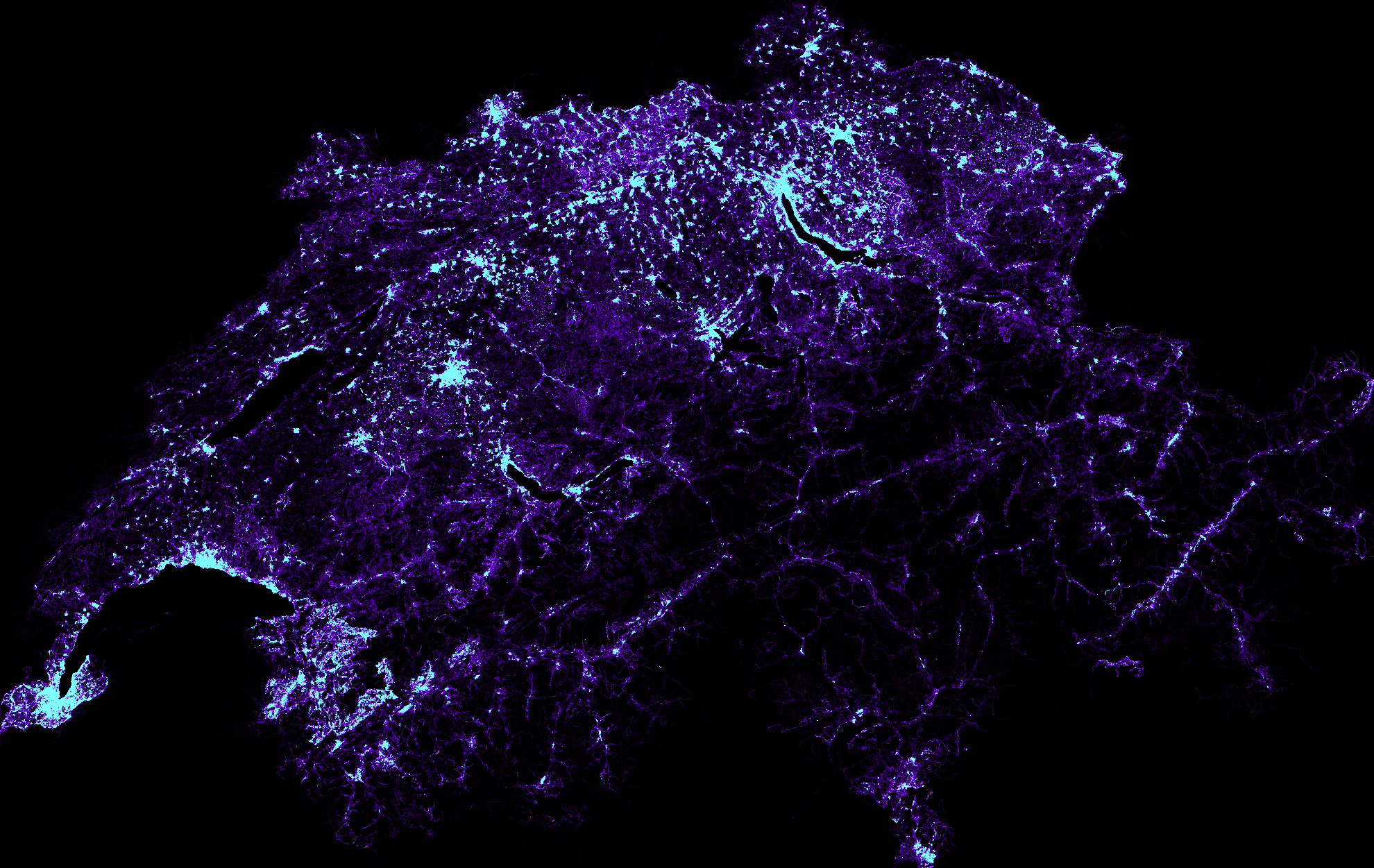
An open street map node density map for Switzerland

I'd like to know how open street map nodes are distributed in Switzerland, that is, I want to map their density on an image. This should be a fairly easy task with Python since I have already loaded Switzerland into an sqlite database (See OpenStreetMap: convert an pbf to an sqlite database with Python and download-switzerland-pbf.py [github]).

First, I create a table that contains the count of nodes per pixel. I fill this this table with a create table... as ...count(*).... group by. The values for the variables a through f determine the aspect ration and the size of the resulting picture:

create table count_per_pixel_ch as select count(*) cnt, cast ( ( lon - a ) / c * e as int) x, cast ( ( lat - b ) / d * f as int) y from node group by x, y;

x and y are unique. This pair represents a pixel on the final image. cnt is the number of nodes that fall into the area covered by a x/y pair.

After filling this table, I can iterate over each pixel and draw a color that is lighter for large pixel counts and darker for small pixel counts. I use the Python Image Library (import Image) to draw the image.

import Image # # Code filling the table # for r in cur.execute(""" select x, y, cnt from count_per_pixel_ch where x >= 0 and x < {image_width_px} and y >= 0 and y < {image_height_px} """.format( image_width_px = image_width_px , image_height_px = image_height_px)): x = r[0] y = image_height_px - r[1] - 1 cnt = float(r[2]) blue = int(float(cnt)/float(avg_count_per_pixel) * 255.0) green = 0 if blue > 255: green = blue - 255 blue = 255 pixels[x, y] = (blue/2, green, blue)

Here's the result:

The same picture with a better resolution.

Source code on github

Wednesday, October 1, 2014

A Google Earth hiking map for the Säntis region with Open Street Map data

After I have loaded a Switzerland pbf file (see download-switzerland-pbf.py or download-switzerland-pbf.bat) into an sqlite database (see OpenStreetMap: convert an pbf to an sqlite database with Python ), I can use this data to create a Google Earth kml file that highlights objects found in Open Street Map.

I am particularly intersted in creating an SAC hiking map for the Säntis region. For that end, I chose osm ways that have a tag named sac_scale.
Additionally, I restricted the respective nodes to the lattitude longitude for the Säntis region.

These ways are kept in a specific table:

create table sac_ways_around_saentis as select distinct wy.id way_id from tag tg join way wy on wy.id = tg.way_id join node_in_way nw on wy.id = nw.way_id join node nd on nd.id = nw.node_id where nd.lat > 47.2210118322 and nd.lat < 47.2604651483 and nd.lon > 9.3149215728 and nd.lon < 9.3959004678 and tg.k = 'sac_scale'

With this table, I can now extract the lattitude/longitude pairs for each node in the relevant ways and write them into a kml file.

The algorithm basically boils down to:

select way_id from sac_ways_around_saentis -- with each way_id: select node_id from node_in_way where way_id = ? order by order_ -- with node_id select lat, lon from node where id = ? -- Emit lat, lon into kml file
Of course, I would use a Python script for this (sac_ways_saentis.py on github).

Here's a screen shot of the result:

Tuesday, September 30, 2014

OpenStreetMap: convert an pbf to an sqlite database with Python

Recently, I have demonstrated how the open street map pbf parser (OSMpbfParser.py) can be used to create xml files. With little effort, a script can be written that creates and fills an sqlite database. Of course, I first have to define a schema into which I load the data. I think this is also a good exercise to understand the internals of osm data. The tables are adapted from the original open street data database schema.

Tables

Table node

The node table is the fundamental table for open street map. Each node consists of a longitude (lon) / latitude (lat) pair and thus defines a geographical point on the surface of the earth. The original schema has a few more attributes, such as changeset_id or version. I am not interested in these, so I don't load them:
create table node( id integer primary key, lat real not null, lon real not null );

Tables way and node_in_way

Each "line" (such as a street or border etc) on open street map is an ordered list of nodes. Open Street Map calles them ways. Ways are also used to define areas in which case the last node equals the first node in the list.

First, I need a table just to store each way. Again, I am not interested in attributes such as user or changeset, so I just load the way's id:

create table way( id integer primary key );

The table node_in_way relates nodes and ways:
create table node_in_way( way_id integer not null references way deferrable initially deferred, node_id integer not null references node deferrable initially deferred, order_ integer not null )

Tables relation and member_in_relation

Open Street Map allows to relate multipe nodes and ways (and even relations) in a relation:
create table relation( id integer primary key );

Each member (that is either node, way or relation) is listed in member_in_relation. Thus, exactly one of the attributes node_id, way_id or relation_id is not null:

create table member_in_relation( id_of_relation integer not null references relation deferrable initially deferred, node_id integer null references node deferrable initially deferred, way_id integer null references way deferrable initially deferred, relation_id integer null references relation deferrable initially deferred, role text )

Table tag

Finally, there are tags. A tag is a key (k) value (v) pair that can be assigned to nodes, ways or relations. Often, the values for specific keys define what an object is. As in member_in_relation exactly on of node_id, way_id or relation_id is not null.
create table tag( node_id integer null references node deferrable initially deferred, way_id integer null references way deferrable initially deferred, relation_id integer null references relation deferrable initially deferred, k text not null, v text not null )

ERD

Here's the ERD for these tables:

The ERD was created with dia from pbf2sqlite-erd.dia.

Loading the pbf to a sqlite db

In order to run the script, a pbf must be obtained, for example with download-switzerland-pbf.py.

Then, this pbf can be loaded into a sqlite db on the command line with

pbf2sqlite.py xyz.pbf xyz.db

The script is on github: pbf2sqlite.py.

Parsing an Open Street Map pbf file with Python

Open Street Map: convert pbf to xml

A Google Earth hiking map for the Säntis region with Open Street Map data

An open street map node density map for Switzerland

Monday, September 22, 2014

Open Street Map: convert pbf to xml

Here's an example on how the open street map parser can be used to create xml files. Please excuse the wide source...
import sys import time import OSMpbfParser def xml_escape(s_): s_=s_.replace ("&", "&" ) s_=s_.replace ("<", "<" ) s_=s_.replace (">", ">" ) s_=s_.replace ('"', '"') return s_ def callback_node(node): stamp=time.strftime("%Y-%m-%dT%H:%M:%SZ",time.gmtime(node.time)) if len(node.Tags)>0: fh.write(' \n' % (node.NodeID, node.version, stamp, node.uid, xml_escape(node.user), node.changeset, node.Lat, node.Lon)) for t in node.Tags.keys(): fh.write(' \n' % (t, xml_escape(node.Tags[t]))) fh.write(' \n') else: fh.write(' \n' % (node.NodeID, node.version, stamp, node.uid, xml_escape(node.user), node.changeset, node.Lat, node.Lon)) def callback_way(way): stamp=time.strftime("%Y-%m-%dT%H:%M:%SZ",time.gmtime(way.time)) fh.write(' \n' % (way.WayID, way.version, stamp, way.uid, xml_escape(way.user), way.changeset)) for n in way.Nds: fh.write(' \n' % (n)) for t in way.Tags.keys(): fh.write(' \n' % (t,xml_escape(way.Tags[t]))) fh.write(' \n') def callback_relation(relation): stamp=time.strftime("%Y-%m-%dT%H:%M:%SZ",time.gmtime(relation.time)) fh.write(' \n' % (relation.RelID, relation.version, stamp, relation.uid, xml_escape(relation.user), relation.changeset)) for m in relation.Members: fh.write(' \n' % (m.type, m.ref, xml_escape(m.role))) for t in relation.Tags.keys(): fh.write(' \n' % (t,xml_escape(relation.Tags[t]))) fh.write(' \n') # First argument is *.pbf file name pbf_filename = sys.argv[1] # Second (optional) argument is output file if len(sys.argv) > 2: fh = open(sys.argv[2], 'w') else: fh = sys.stdout fh.write('\n') fh.write('\n') OSMpbfParser.go(pbf_filename, callback_node, callback_way, callback_relation) fh.write('\n') fh.close()

This script takes one mandatory and an optional argument. The mandatory argument specifies the pbf file. If the optional parameter is given, it specifies the name of the xml file into which the output is written, otherwise, the output goes to stdout:
c:\> pbf2xml.py liechtenstein-latest.osm.pbf liechtenstein.xml
Source code on github

open street map parser

OpenStreetMap: convert an pbf to an sqlite database with Python

Parsing an Open Street Map pbf file with Python

Chris Hill at http://pbf.raggedred.net/ has written a parser in Python for open street map pbf files. His parser is free software, so I used this liberty to adapt it for my needs. In particular, his script either collects osm node, way and relation data either in memory (which is a problem for big pbf files) or it emits xml files with the osm data. I have changed his script so that I can pass three callback functions that are invoked as soon as the parser finished with one of the three fundamental osm type node, way or relation.

Here's a template that can be used to write a script that uses my adaption of the parser:

import OSMpbfParser def callback_node(node): do_something_with(node) def callback_way(way): do_something_with(way) def callback_relation(relation): do_something_with(relation) OSMpbfParser.go( 'the-file-to-be-parsed.pbf', callback_node, callback_way, callback_relation)

Each of the callback functions has exactly one parameter that corresponds to the classes OSMNode, OSMWay and OSMRelation (see the source at github).

Installing google's protocol buffers

To parse pbf files, google's protocol buffers are needed. The can be optained from code.google.com/p/protobuf/downloads/list.
For Windows, I downloaded protoc-2.5.0-win32.zip which contains one file: protoc.exe. After extracting this file, the environment variable PATH should be changed so that it points to the directory with protoc.exe.

For the python installation, the full source protobuf-2.5.0.tar.bz2 is also needed. After extracting them, cd into the python directory and execute:

cd protobuf-2.5.0\protobuf-2.5.0\python python setup.py build python setup.py test python setup.py install
Source code on github

convert pbf files to xml

OpenStreetMap: convert an pbf to an sqlite database with Python